|
|
|||||
|
Using
Soil Erosion Modeling for Improved Conservation Planning: |
|||||
|
|
|||||
|
Using
Soil Erosion Modeling for Improved Conservation Planning: |
|||||
Methods and Algorithms
The amount of eroded and transported soil is controlled by the capacity of water flow to detach and move soil through the landscape. Depending on the relationship between the detachment and transport capacity of water flow, erosion processes can be modeled as either detachment or transport capacity limited.
 |
Detachment limited methods assume that water flow can transport an infinite amount of sediment, and that the amount of eroded soil is limited only by the capacity of water to detach soil. Because of this assumption no deposition is predicted. This case is modeled by USLE and RUSLE. The outputs of these models are often used as estimates of soil detachment and input into models that route the detached soil through the watershed (e.g., CASC2d and ANSWERS). The modification for complex terrain and GIS is described as RUSLE3D. |
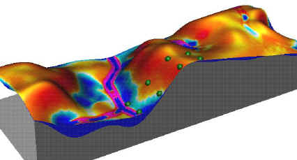 |
Transport capacity limited methods assume that water flow can transport a limited amount of sediment given by the transporting capacity of water flow. These methods also assume that the amount of sediment carried by water is always at its full transporting capacity. Therefore in the locations where transport capacity increases, erosion is predicted; where transport capacity decreases, sedimentation occurs. This case is modeled by USPED and some geomorphological models. |
 |
General models simulate erosion processes between the detachment and transport capacity limited cases, and are spatially variable depending on the interaction between the topography, soil, cover, water flow velocity and amount of sediment carried by water. Examples of general models include SIMWE, CASC2D, WEPP, and LISEM. |
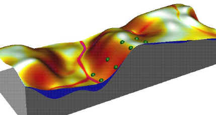
The detachment limited case is more probable for large rainfall events when the transport capacity of water flow is high. The transport capacity limited case is typical for long term erosion and deposition patterns, which include the effects of both large and small rainfall events. The detachment limited case is characteristic for soils with very small particles such as clays (assuming minimum aggregation), whereas the transport capacity limiting case better describes the behavior of sandy soils with larger particles. The first two special cases are easier to compute than the general case, and they can be used as estimates of the minimum and maximum spatial extent of deposition for the given landscape. Areas that are identified as high risk from both models should be targeted for field inventory. If the high risk is confirmed, conservation measures should be implemented in these areas.
|
|


