|


|
|
Using
Soil Erosion Modeling for Improved Conservation Planning:
A GIS-based
Tutorial
|
Erosion
processes at multiple scales
and related models
Erosion and sediment transport are multi-scale, with different types of processes
dominant at different scales. The scales can range from
raindrops to entire continents. However, from the point of view of land use
management
the scales ranging from a field to a region are most important. For each scale it is possible
to model the dynamics of erosion processes during a rainfall event, or a steady
state averaged estimate.
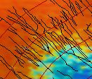 Plot and Field Scale: Spatial Resolution = 1cm-1m
Sheet, rill and gully
erosion are distinguished and are usually modeled individually.
In advanced models, rills and gullies are simulated as dynamic, evolving 3D features.
Changes in elevation are captured even for short time periods (e.g. a single rainfall event). Spatial variability
in land cover (vegetation density, canopy, stones, roots) is incorporated,
as well as human impacts, such as vehicle tracks or ditches. All conservation
measures are represented by their shape and properties (e.g., contour
filter strips, grassways, hedges, dry dams). The goal of modeling is detailed
assessment and prediction of different types of erosion and deposition,
especially for design of conservation measures.
Examples of models: RillGrow2,
USLE/RUSLE, EUROSEM, Kineros,
WEPP hillslope, SIMWE, USPED.
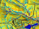 Landscape and Small Watershed Scale: Spatial Resolution = 5m-20m
Sheet, rill and small gully
erosion are averaged and modeled as overland flow erosion. Only large gullies
are captured. Variability in topography (convex/concave
features) is important. Spatial variability in land cover is also averaged
and only larger man made features are explicitly modeled.
Anthropogenic features, conservation
measures and other land cover features that would require higher resolution
(e.g., dirt roads, ditches, tracks, grassways, hedges) are usually captured via factors
that increase or reduce detachment and sediment transport. When modeling erosion
and deposition over short time periods, the changes in topography are neglected. Stream routing
may be included. The typical goal of modeling at this scale is conservation/land use planning
and erosion/deposition risk assessment.
Examples of models: RUSLE3D, USPED, WEPP Watershed, SIMWE, LISEM, CHILD, CASC2d.
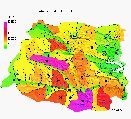 Regional Scale, Large Watersheds: Spatial Resolution >20m
Sheet, rill and concentrated
flow erosion are averaged, often into homogeneous hydrologic units (i.e.
subwatersheds
and their subareas) or other homogeneous spatial units (e.g., grid cells, triangles,
Voronoi
polygons, hillslope segments) and expressed as total soil detachment and sediment transport
for each of these units. The impact of spatial
variability in land cover is averaged and often expressed only as
a percentage of the given area independent of the location. Stream processes
dominate at this resolution. The goal of modeling is assessment and planning
at the regional level, identifying spatial units (subwatersheds) with
high risk and designating large conservation areas.
Examples of models: SWAT, BASIN,
modified versions of
AGNPS, ANSWERS
and averaged or simplified versions
of high resolution models (RUSLE, WEPP, SIMWE).
Acknowledgements
Summary of Soil Erosion Modeling Tutorial
Introduction
Example Applications of Erosion Modeling
Methods and Algorithms
Processing Input Data for Erosion Modeling
Erosion processes at multiple scales and related models
Modeling erosion at multiple scales
Analyzing and communicating the modeling results
Troubleshooting
|
 HOME
H. Mitasova, et al., Geographic
Modeling Systems Lab, UIUC HOME
H. Mitasova, et al., Geographic
Modeling Systems Lab, UIUC
|