|
|
|||||
|
Using
Soil Erosion Modeling for Improved Conservation Planning: |
|||||
|
|
|||||
|
Using
Soil Erosion Modeling for Improved Conservation Planning: |
|||||
Troubleshooting
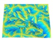
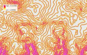 A DEM with elevation values given as integer meters produces a slope map as shown in this
image, where areas of zero slope are combined with steeper areas along 1m contours.
The zero slope areas are caused by insufficient vertical resolution and
will result in underestimation of erosion (see the tables shown for the "Large
areas with zero erosion" section). The best solution is to find a more
accurate DEM, preferably with centimeter vertical precision. If it is not available,
the DEM should be reinterpolated either from contours generated from the DEM or
random samples with sufficient smoothing. Note, that the contours generated from
a DEM have very dense sampling compared to manually digitized
ones. Reducing the density of points reduces the problems
with the contour-like pattern in the slope maps.
A DEM with elevation values given as integer meters produces a slope map as shown in this
image, where areas of zero slope are combined with steeper areas along 1m contours.
The zero slope areas are caused by insufficient vertical resolution and
will result in underestimation of erosion (see the tables shown for the "Large
areas with zero erosion" section). The best solution is to find a more
accurate DEM, preferably with centimeter vertical precision. If it is not available,
the DEM should be reinterpolated either from contours generated from the DEM or
random samples with sufficient smoothing. Note, that the contours generated from
a DEM have very dense sampling compared to manually digitized
ones. Reducing the density of points reduces the problems
with the contour-like pattern in the slope maps.
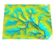
 A DEM interpolated from dense points along contour lines may generate a
slope map such as this, which overestimates flat areas and
contains lines along the contours of artificial drops, forming terraces.
This does not represent the natural landscape, and will usually
result in underestimation of sheet erosion because flat areas are overestimated.
The DEM should be reinterpolated using different parameters or a different
method. When using splines, lower tension and higher smoothing
will reduce waves along contours.
A DEM interpolated from dense points along contour lines may generate a
slope map such as this, which overestimates flat areas and
contains lines along the contours of artificial drops, forming terraces.
This does not represent the natural landscape, and will usually
result in underestimation of sheet erosion because flat areas are overestimated.
The DEM should be reinterpolated using different parameters or a different
method. When using splines, lower tension and higher smoothing
will reduce waves along contours.
 Using smoothing techniques during interpolation of the DEM and
thinning the sample points along the contour will
reduce the terracing effect somewhat. The best DEMs are produced not from
contour data, but from more evenly spaced sampling methods such as IFSARE (for areas
without vegetation) or LIDAR, or from contours combined with breaklines,
surface specific points (peaks, depressions) and mass points.
Using smoothing techniques during interpolation of the DEM and
thinning the sample points along the contour will
reduce the terracing effect somewhat. The best DEMs are produced not from
contour data, but from more evenly spaced sampling methods such as IFSARE (for areas
without vegetation) or LIDAR, or from contours combined with breaklines,
surface specific points (peaks, depressions) and mass points.
Lower exponents for m and n may be needed. The empirical constants used
in the models were derived from experimental plots that were much shorter
than the length of slopes commonly observed at landscape scale. While the exponents m=0.4 and n=1.3 should give reasonable results for RUSLE3D,
it is useful to have a few sample areas with field observations of the
erosion rates so that these exponents can be adjusted to the flow type
typical for the study area.
Finally, erosion models used in this tutorial were originally designed for sheet and rill erosion caused by shallow overland flow. The implementation of upslope contributing area enables application of these models in complex terrain where concentrated flow is quite common in hollows and valleys. Erosion rates in these areas is much higher and exceed the typical values obtained by RUSLE or USLE. These higher erosion rates may be realistic, however, extensive field testing similar to those done for USLE is not available to verify the values. Due to this uncertainty, especially if it is impossible to verify the values in the field, it is recommended that erosion rates predicted for concentrated flow areas are reclassified to values expected for gullies in the studied area. This reclass procedure affects only a very small number of grid cells and has little impact on erosion averages for the entire region. However, it is important to keep these areas in the maps and reports, as they can contribute substantial amount of sediment to the total loads and should be the primary targets for erosion prevention and conservation.
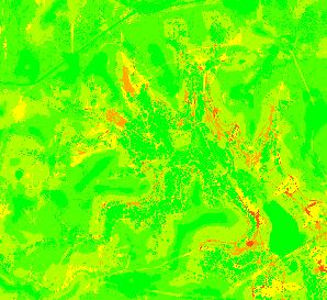
| When you compute RUSLE3D you may get a map like this if you use the default color table |
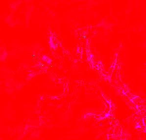
|
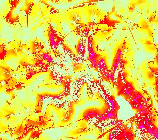
| You may try to change to one of the color tables provided by GIS, for example, a red/yellow/green ramp, however, the result won't be much better because the colors are evenly spread between the minimum and maximum erosion, but most of the spatial variability is at the low range of values (e.g. 0-20). |

|
| A better solution is to reclassify the map so that the large interval of high values is merged into a single class, for example, like in this table. Then you can apply the standard red/yellow/green ramp and areas with high erosion will pop-up in orange. However, your map now only has 6 values and some spatial variability has been lost. |
|
| The best results are obtained when the color table is defined manually (see suggested color tables for RUSLE3D and USPED) |
|
| The image to the right illustrates the difference between a linear and non-linear color table, where the upper legend is the RYG ramp and the lower legend is the one used for our RUSLE3D results: |
|
| This problem is restricted to the use of ArcView or ArcGIS flowacc module for computation of flow accumulation and is a consequence of the D8 flow routing algorithm that moves water only in 8 discrete directions. |
|
| The problem can be reduced by increasing the grid cell size (decreasing resolution), however, some detail will be lost. A better, although more time consuming, solution is to use one of the ArcView flow tracing or hydrologic modeling extensions with D-infinite or multiple flow paths routing algorithm. |
|
| Also the most recent version of GRASS5 with easy to install binaries for Linux, Mac OS X and Windows can be used. You can import the DEM into GRASS, run the command r.flow, and export the resulting flow accumulation map. The exchange of raster files between the two systems is quite easy. |
|
Compare the erosion estimates derived from RUSLE3d when using the DEM with integer meter resolution (67% of the area is stable) and with a reinterpolated and smoothed DEM (only about 22% of the area is stable):
DEM given in integer meters
|----------------------------------------------------------|
|           Category Information         |   %  |          |
|         #|description                  | cover|     acres|
|----------------------------------------------------------|
|-2010--100|extreme. . . . . . . . . . . |  0.38|   6.27117|
|  -100--50|severe . . . . . . . . . . . |  1.18|  19.36020|
|   -50--20|high . . . . . . . . . . . . |  2.65|  43.48044|
|    -20--5|moderate . . . . . . . . . . | 10.04| 164.77722|
|     -5--1|low. . . . . . . . . . . . . | 16.11| 264.42489|
|      -1-0|stable . . . . . . . . . . . | 67.79|1112.87790|
|         *|no data. . . . . . . . . . . |  1.86|  30.51364|
|----------------------------------------------------------|
|TOTAL                                   |100.00|1641.70546|
+----------------------------------------------------------+
Average soil loss is 3.7 tons/acre year which may be still acceptable.
|----------------------------------------------------------|
|           Category Information         |   %  |          |
|         #|description                  | cover|     acres|
|----------------------------------------------------------|
|-2010--100|extreme. . . . . . . . . . . |  0.49|   8.03119|
|  -100--50|severe . . . . . . . . . . . |  2.46|  40.38263|
|   -50--20|high . . . . . . . . . . . . |  5.42|  88.98757|
|    -20--5|moderate . . . . . . . . . . | 31.28| 513.58741|
|     -5--1|low. . . . . . . . . . . . . | 36.35| 596.79047|
|      -1-0|stable . . . . . . . . . . . | 21.74| 356.83027|
|         *|no data. . . . . . . . . . . |  2.26|  37.09593|
|----------------------------------------------------------|
|TOTAL                                   |100.00|1641.70546|
+----------------------------------------------------------+
Average soil loss is 8.6 tons/acre per year indicating an unsustainable level of erosion.
|
|


