|
|
|||||
|
Using
Soil Erosion Modeling for Improved Conservation Planning: |
|||||
|
|
|||||
|
Using
Soil Erosion Modeling for Improved Conservation Planning: |
|||||
![]() DEM
DEM
Color table stored in GRASS data base

% 269.83 319.13
269.83:0:191:191 279.69:0:255:0
279.69:0:255:0 289.55:255:255:0
289.55:255:255:0 299.415:255:127:0
299.41:255:127:0 309.277:191:127:63
309.27:191:127:63 319.13:20
![]() Slope
Slope
Color table stored in GRASS data base

% 0 20
0:255 2:255:255:0         white
2:255:255:0 4:255:127:0   yellow
4:255:127:0 6:255:0:0     orange
6:255:0:0 8:255:0:255     red
8:255:0:255 20:127:0:255  magenta
Upslope area

Rules
>-1 black
> 0 white
> 5 yellow
> 30 cyan
>100 aqua
>1000 blue
>50000 black

Color table stored in GRASS data base
% -1 48713
-1:0
0:255 5:255:255:0
5:255:255:0 30:0:255:255
30:0:255:255 100:0:127:255
100:0:127:255 1000:0:0:255
1000:0:0:255 48713:0

Rules
> 0 200 255 200 (light green)
> 5 yellow
> 20 orange
> 50 red
> 100 magenta
>1000 violet

Color table stored in GRASS data base
% 0 1000
0:200:255:200 5:255:255:0
5:255:255:0 20:255:127:0
20:255:127:0 50:255:0:0
50:255:0:0 100:255:0:255
100:255:0:255 1000:127:0:255
 net deposition (blue) and erosion(red)
note: the values are for erosion/deposition*10 computed with m=1.4
Color table stored in GRASS data base
% -7000 7000
-7000:255:0:255 -100:255:0:0
-100:255:0:0 -10:255:127:0
-10:255:127:0 -1:255:255:0
-1:255:255:0 0:200:255:200
0:200:255:200 1:0:255:255
1:0:255:255 10:0:191:191
10:0:191:191 100:0:0:255
100:0:0:255 7000:0
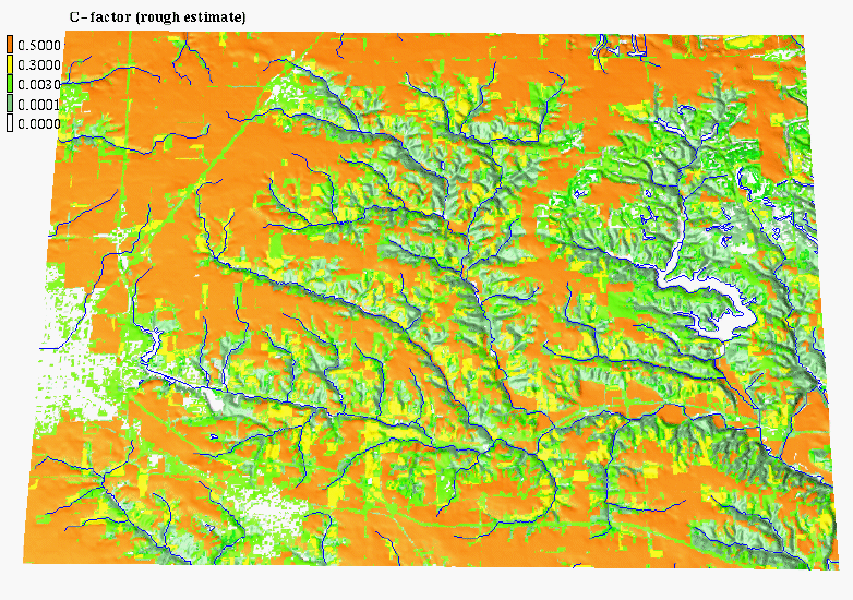
Color table stored in GRASS data base
% 0 0.5
0:0:191:191 0.001:0:255:0
0.001:0:255:0 0.003:255:255:0
0.003:255:255:0 0.3:191:127:63
0.3:191:127:63 0.5:255:0:0
Color table stored in GRASS data base
% 0.17 0.4
0.17:255:255:0 0.28:191:127:63
0.28:191:127:63 0.32:255:0:0
0.32:255:0:0 0.4:255:0:255
|
|


