|
|
|||||
|
Using
Soil Erosion Modeling for Improved Conservation Planning: |
|||||
|
|
|||||
|
Using
Soil Erosion Modeling for Improved Conservation Planning: |
|||||
Computing
USPED using GIS
Display Notes:
ArcGIS 8.1,
ArcMap
Given data


grid:
elevation
Kfac
Cfac
(P)
constant: R=120, resolution=10


Computation
1. Enable Spatial Analyst
Under View... Toolbars select Spatial Analyst
2. Calculate Slope and Aspect
From the Spatial Analyst toolbar, select Surface
Analysis... Slope
Enter the elevation layer, select Degree, and enter
output information.
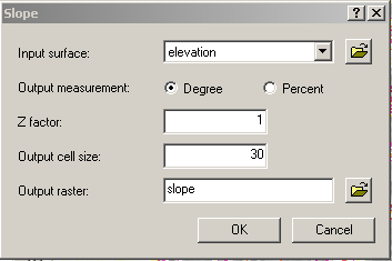
Give the new theme
name slope
From the Spatial
Analyst toolbar, select Surface Analysis... Aspect
Give the new theme name aspect
3. Raster Calculator
From the Spatial Analyst toolbar, select Raster Calculator
Build an expression:
FlowAccumulation(FlowDirection([elevation]))
Evaluate
Make the new theme permanent and change the name to flowacc
Build an expression in the Raster Calculator
Note: to get contributing area per unit width we multiply by cell area and divide by resolution
leading to mult. by resolution below. The width unit [m] cancels out in steps 4-6 by computing
the directional derivative leading to final erdep rate per cell in ton/acre.year, for 10m cell
divide by 4046 to get ton/year eroded from a grid cell
(!!! skip conversion to radians - multiplication by 0.01745 - in ArcGIS9.2 in all expressions below):
(for prevailing rill erosion):
Pow([flowacc] * resolution , 1.6) * Pow(Sin([slope]
* 0.01745) , 1.3)
Evaluate
Make the new theme permanent and change the name to sflowtopo
(for prevailing
sheet erosion):
[flowacc] * resolution * Sin([slope] * 0.01745)
Evaluate
Make the new theme permanent and change the name to sflowtopo
Build an expression in the
Raster Calculator:
note: R changed from the original 280 to R=120 (Oct 28, 2008)
[sflowtopo] * [kfac] * [cfac] * 120 * Cos((([aspect]
* (-1)) + 450) * .01745)
Evaluate
Make the new theme permanent and change the name to qsx
Build an expression in the
Raster Calculator:
[sflowtopo] * [kfac] * [cfac] * 120 * Sin((([aspect]
* (-1)) + 450) * .01745)
Evaluate
Make the new theme permanent and change the name to qsy
4. Select qsx in the Spatial
Analysis Toolbar
Select Surface Analysis... Slope
Give the new theme name qsx_slope
Select Surface Analysis... Aspect
Give the new theme name qsx_aspect
5. Select qsy in the Spatial
Analysis Toolbar
Select Surface Analysis... Slope
Give the new theme name qsy_slope
Select Surface Analysis... Aspect
Give the new theme name qsy_aspect
6. Raster Calculator
Build an expression
Cos((([qsx_aspect] * (-1)) + 450) * .01745) * Tan([qsx_slope]
* .01745)
Give the new theme name qsx_dx
Build an expression
Sin((([qsy_aspect] * (-1)) + 450) * .01745) * Tan([qsy_slope]
* .01745)
Give the new theme name qsy_dy
Build an expression
[qsx_dx] + [qsy_dy] for prevailing rill erosion
Give the new theme name erdep
([qsx_dx] + [qsy_dy]) *
10. for prevailing sheet erosion
Give the new theme name erdep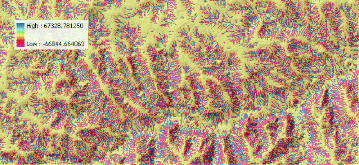
![]() HOME
H. Mitasova, et al., Geographic
Modeling Systems Lab, UIUC
HOME
H. Mitasova, et al., Geographic
Modeling Systems Lab, UIUC


