 GeoISEM Home
Spatial modeling and analysis of nearshore environment using Open source GIS
Helena Mitasova and Tom Drake
GeoISEM Home
Spatial modeling and analysis of nearshore environment using Open source GIS
Helena Mitasova and Tom Drake
Department of Marine, Earth and Atmospheric Sciences North Carolina
State University Raleigh NC
email: hmitaso@unity.ncsu.edu
Coastal studies involve processing, analysis and visualization of large
spatial data sets, often in different computational environments, coordinate
systems and formats. Geographic Information System (GIS) as a tool for
management of georeferenced data, is a natural choice for integration of
these heterogeneous data. However, the traditional concept of a 2D static
GIS is not sufficient and extension of GIS capabilities is needed. Recent
developments in Open Source GIS as well as the industry-wide moves towards
open, extendable GIS created opportunities to enhance and develop new tools
suitable for coastal applications.
The presentation focus is on evaluation and enhancements of Open source
GIS methods and tools for spatial interpolation (gridding) of coastal data
with simultaneous analysis of terrain geometry using
Regularized Spline with Tension and visualization.
Surface geometry analysis which includes the computation of slope, aspect, various types
of curvatures as well as partial derivatives, can be performed at various
levels of detail. GRASS GIS visualization is demonstrated by
interactive analysis of measured data and models, using multiple surfaces,
cutting planes, lighting and spatial query as powerful tools for gaining
better understanding of measured data and studied phenomena.
The link between process modeling and GIS is discussed using
our experience with multiscale spatial modeling of surface hydrology and
overland flow erosion, using path sampling method and possible coastal
applications will be discussed.
The Open source GIS tools will be illustrated by applications to LIDAR
coastal data, Real Time Kinematic Survey measurements and other types of
coastal and nearshore mapping.
powerpoint presentation
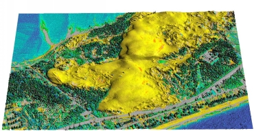
Jockey's Ridge interpolated by RST from LIDAR (data from ...NOAA)