
 Rainfall Runoff (movie - 99,405 bytes)
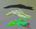
 In this visualization, three surfaces are used to show the dynamics of a rainfall event as it moves uphill. The top surface represents rainfall intensity, the middle surface shows terrain draped with color that represents water accumulation, and the bottom surface represents water infiltration depth. Together the three surfaces create a visual paradigm (sky, surface, subsurface) that provides viewers with an intuitive way to analyze the data during the animation. Notice how the maximum water accumulation on the middle surface occurs well after the storm has passed.
 GMSL Modeling & Visualization