
 developed with GRASS5.0
Interpolation and simulation of terrain development with hedges
Helena Mitasova, Lubos Mitas, University of Illinois at Urbana-Champaign
in cooperation with Seth M. Dabney, USDA-ARS National Sedimentation
Lab, Oxford, MS
Copyright © 2000 Helena Mitasova, GMS Laboratory,
University of Illinois at Urbana-Champaign
For requests to use this material or its parts please
contact: helena@gis.uiuc.edu
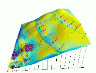
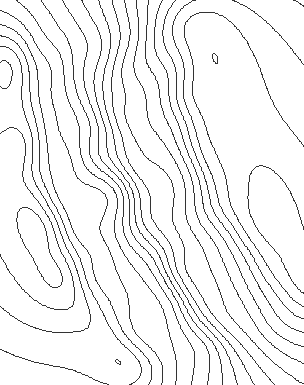
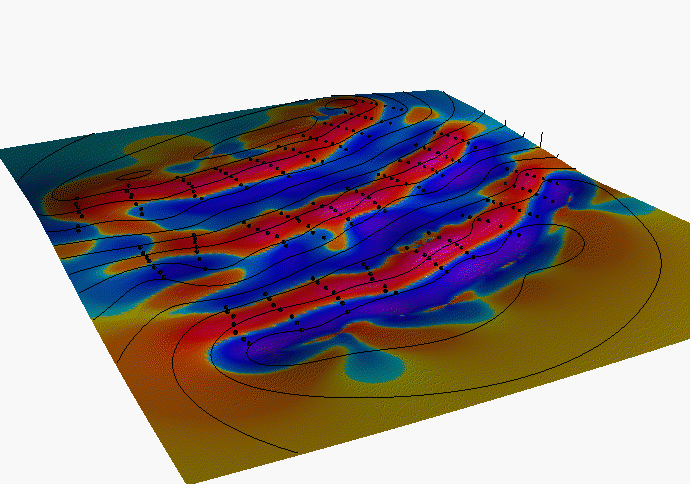
1. Digital elevation model, slope and curvature
DEMs and topographic parameters were computed from field measured point
data by the RST method (s.surf.rst) in GRASS5.0, at 0.4m resolution, displayed at 2x
vertical exagerration
Dynamics of DEM and slope development on a tilled hillslope with hedges
from 1993 - 1996
movie in mpeg format or animated gif
Notes on interpolation
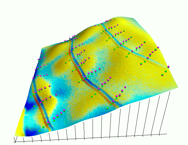
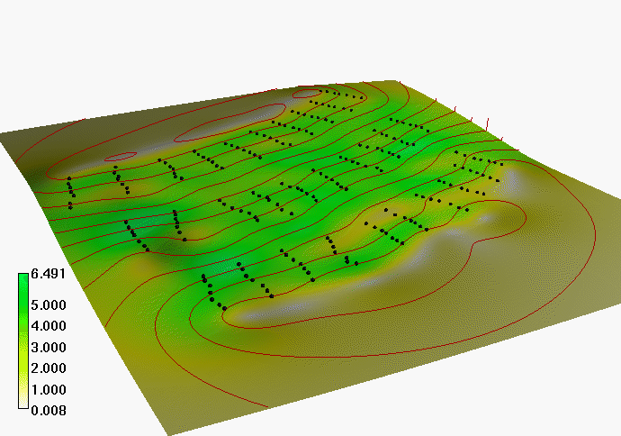
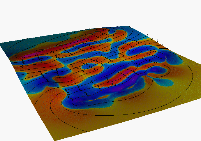
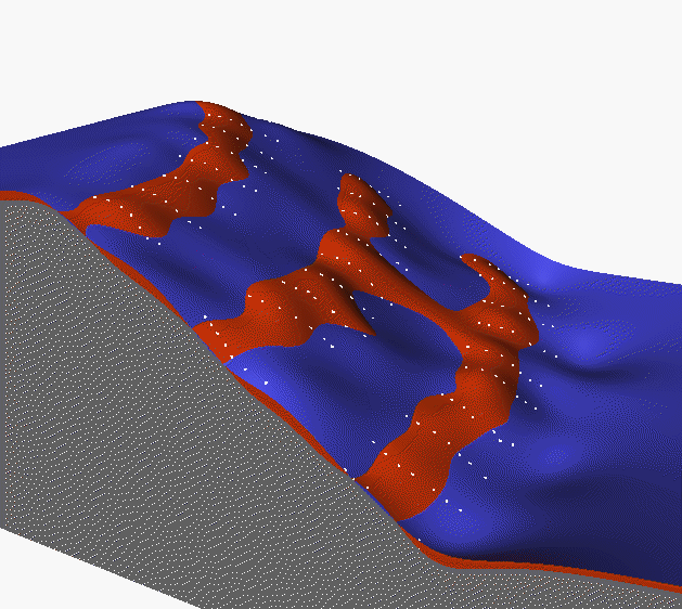
2. Simulation experiments
The SIMWE model (Mitas and Mitasova
1998) was used to simulate the impact of hedges under various simplified
conditions. Hedges are 3 cells (1.2m) wide located along contourline running
through the 3rd site from the bottom of each profile. Red spheres show the measured
elevation in 1996, green spheres show elevation in 1993 at the start of
simulation. Cyan - blue is deposition, yellow-red is erosion.
-
Terrain and erosion/deposition pattern development for 7 steady-state events
with uniform rainfall excess 36mm/hr, and Mannings n=0.2(hedge) and n=0.15(field),
with elevation change proportional to predicted erosion/deposition rate.
The model predicts deposition above and within the hedge and erosion below
the hedge. Swales have increased deposition while noses (convex areas)
have increased erosion.
Sequence of images representing terrain and erosion/deposition after 1, 3 and 6 events:
 1
1
 2
2
 3
3
Animation of terrain and erosion/deposition pattern development for
all 7 events
animated gif or mpeg movie
Note, that without the smoothing effect of tillage, smaller events,
wind or other phenomena between the rainfall events the model predicts
development of rills, in spite of the fact that rilling is not explicitely
incorporated into the model - it appears spontaneously. Closer
look at the model is needed to find out whether the method really simulates
(at least approximately) the development of rills or whether this is
just the effect of the numerical solution of the equations governing the
overland flow.
-
Terrain and erosion/deposition pattern for one steady-state event
with uniform rainfall excess 36mm/hr
and Mannings for hedge 0.2 and for the field 0.05. The four times higher
Mannings for hedge (without taking into account higher infiltration)
causes sharp increase in water depth within the hedge and
consequent erosion ABOVE and below the hedge. In the field experiment,
hay bales were placed each 9m perpedicular to the hedge to prevent the
water flow along the hedge, so the predicted effect seems to be realistic.
 Erosion/deposition pattern
for this case, draped over terrain 1993
Erosion/deposition pattern
for this case, draped over terrain 1993
-
same as previous with variable rainfall excess
- 4 times smaller in the hedge due to infiltration.
Erosion/deposition pattern
for spatially variable infiltration
Note: The simplified conditions
were chosen so that the impact and interaction of different properties
can be studied and demonstrated.
References
-
Seth M. Dabney et al. 1999
Lanscape Benching from Tillage Erosion Between Grass Hedges, in press
-
Mitas, L., Mitasova, H., 1999, Spatial
Interpolation. In: P.Longley, M.F. Goodchild, D.J. Maguire, D.W.Rhind
(Eds.), Geographical Information Systems: Principles, Techniques, Management
and Applications, GeoInformation International, Wiley, 481-492.
-
Mitas, L.,
Mitasova, H., 1998, Distributed erosion modeling for effective erosion
prevention Water Resources Research Vol. 34, No. 3, pp. 505-516.
 GMSL Home Page
 GMSL Modeling & Visualization Home Page
 animated gif or mpeg movie
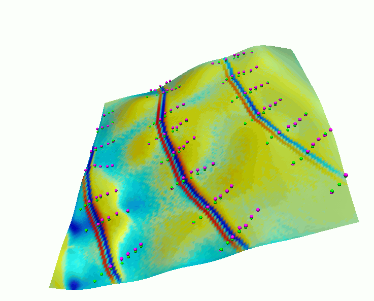 Erosion/deposition pattern
for this case, draped over terrain 1993
Erosion/deposition pattern
for this case, draped over terrain 1993
 1
1 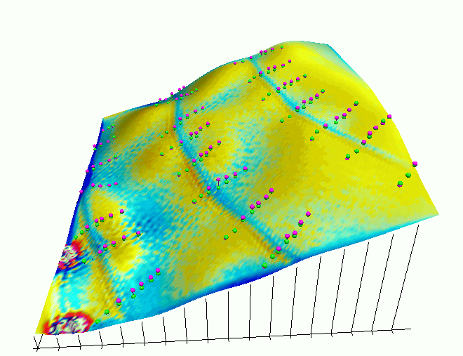 2
2  3
3 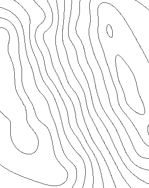