NAME
-
d.siter -
Interactively displays subsets of a sites list
based on site attributes
(GRASS Display Program)
SYNOPSIS
-
d.siter
d.siter help
d.siter name
DESCRIPTION
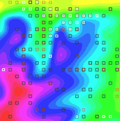
- When the display button is chosen, the GRASS program d.sites.qual is called with rules derived from the current state of the interface and the specified subset is drawn in the active GRASS monitor. By adjusting the size, color and type of marker and drawing multiple subsets, the user may more easily visualize spatial relationships of various subsets or determine inconsistant attribute values.
- Subsets may be saved by entering a filename in the text entry box of the interface and choosing save as:.
- Due to the limited resolution of sliders and considering the wide range and distribution often found in site attribute data, a rescale button is provided. Choosing rescale results in the currently defined ranges becoming the new min and max and the sliders being reset to their left and right extremes, allowing further refinement of the range.
- To undo the rescale operation, the user may select reset scales which resets all scales to their startup values (loosing any ranges already specified).
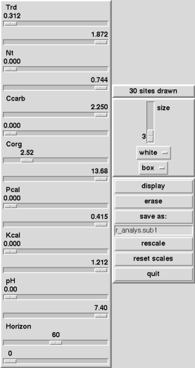 d.siter is a script which calls s.info
to determine the
number, types and ranges of site attributes, then calls a
tcl script which presents a user interface. On the
interface there are two sliders for each dimension,
category, or decimal attribute in the sites file. If a
header with labels is in the file, the sliders will be
labeled. The value range for each slider pair is determined
by the range for the corresponding attribute found in the
sites file for sites within the current region. At startup
one slider in each pair is set at the minimum value and the
other slider is set at the maximum value. The user adjusts
sliders as needed to set ranges of desired values for each
attribute, dimension, or category. The interface also has
controls for setting the size, color, and type of marker,
and buttons for display,
erase, reset scales,
and quit.
d.siter is a script which calls s.info
to determine the
number, types and ranges of site attributes, then calls a
tcl script which presents a user interface. On the
interface there are two sliders for each dimension,
category, or decimal attribute in the sites file. If a
header with labels is in the file, the sliders will be
labeled. The value range for each slider pair is determined
by the range for the corresponding attribute found in the
sites file for sites within the current region. At startup
one slider in each pair is set at the minimum value and the
other slider is set at the maximum value. The user adjusts
sliders as needed to set ranges of desired values for each
attribute, dimension, or category. The interface also has
controls for setting the size, color, and type of marker,
and buttons for display,
erase, reset scales,
and quit.
This program can be run non-interactively or interactively. If the user gives the name of a GRASS site_lists map on the command line the program will be run non-interactively. Alternately, the user can type simply d.siter on the command line; in this case, the program will prompt the user for a site_lists map.
BUGS
-
Due to pixel rounding, startup ranges for sliders may be
slightly off for floating point attributes. The slider min
value will be slightly lower than the min value found in the
file and the slider max value will be slightly higher.
SEE ALSO
-
d.mon, d.sites, d.sites.qual,
s.info
AUTHOR
-
Bill Brown, UI GMS Laboratory