
 developed
with GRASS5.0developed
with GRASS5.0
developed
with GRASS5.0developed
with GRASS5.0Copyright© Helena Mitasova 1999
where E [ton/(acre.year)] is the average soil loss,
R [hundreds of ft.tonsf.in/acre.hr.year] (in SI: [MJ.mm/ha.hr.year
], R[SI]=17.02R[EU]) is the rainfall intensity factor, K
[tons per acre per unit R] = [tons.acre.hr/hundreds.acre.ft.tonsf.in]
is the soil factor, LS [dimensionless] is the topographic
(length-slope) factor, C [dimensionless] is the cover
factor and P[dimensionless] is the prevention practices factor.
Various modifications of this equation are often applied to the estimation
of soil loss using GIS (Warren et al. 1989).
Revised USLE - RUSLE uses the same empirical principles as USLE, however
it includes numerous improvements, such as monthly factors, incorporation
of the influence of profile convexity/concavity using segmentation of irregular
slopes, improved empirical equations for the computation of LS factor (Foster
and Wischmeier1974, Renard et al. 1991).
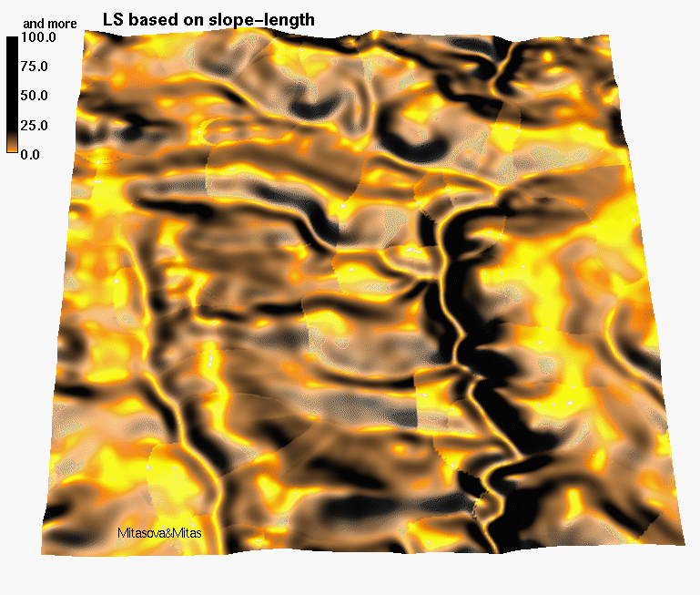
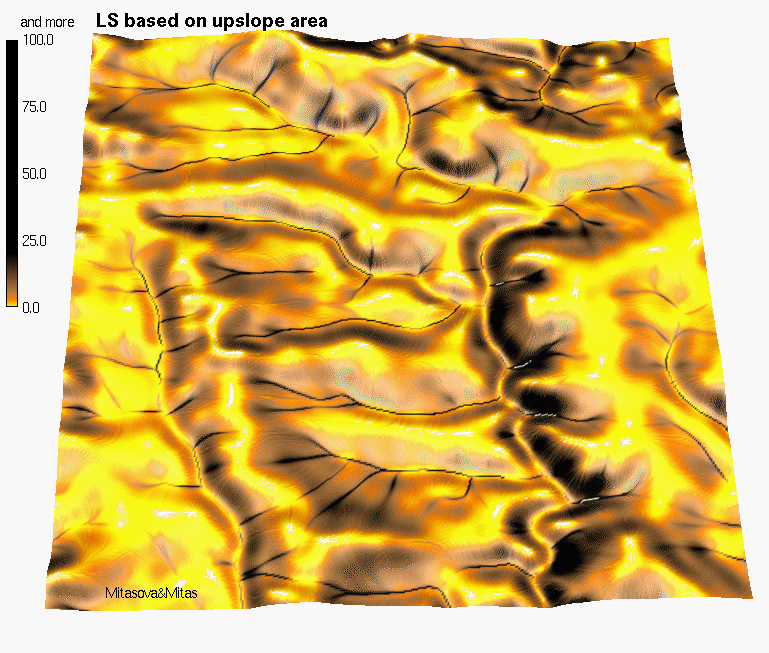
where A[m] is upslope contributing area per unit contour width, b [deg] is the slope, m and n are parameters, and a0 = 22.1m = 72.6ft is the length and b0 = 0.09 = 9% = 5.16deg is the slope of the standard USLE plot. Impact of replacing the slope length by upslope area is illustrated in FIGURE 1 (Length-based LS,Upslope area based LS) which shows that the upslope area better reflects the impact of concentrated flow on increased erosion. It has been shown that the values of m=0.6, n=1.3 give results consistent with the RUSLE LS factor for slope lengths <100m and slope angles <14 deg (Moore and Wilson 1992), for slopes with negligible tangential curvature. Exponents m and n can be calibrated if the data are available for a specific prevailing type of flow and soil conditions.
Both the standard and modified equations can be properly
applied only to areas experiencing
net erosion. Depositional areas should be excluded from the
study area because the model assumes that transport capacity exceeds
detachment capacity everywhere and erosion and sediment transport is detachment
capacity limited. Therefore, direct application of USLE/RUSLE to complex
terrain within GIS is rather restricted. The results can also be interepreted
as an extreme case with maximum spatial extent of erosion possible.
raster: elevation, K, C, (P)
constants: R=120, resolution=10Computation
Copyright© Helena Mitasova 1999
1. r.flow elevation dsout=flowacc
2. r.slope.aspect elevation slope=slope
3. r.mapcalc
lsfac=1.6*exp(flowacc*resolution/22.1,0.6)*exp(sin(slope)/0.09,1.3)
soilloss=R*K*C*P*lsfac
4. Optional: create new colortable, reclass to erosion risk classes, run statistics...
Given data
grid: elevation, K, C, (P)
constant: R=120, resolution=10Computation
1. select elevation
under Analysis select DERIVE SLOPE
give the new theme name slope
2. MAP CALCULATOR
build an expression
([elevation].FlowDirection(FALSE)).FlowAccumulation(NIL)
Evaluate
give the new theme name flowacc
build an expression :
(([flowacc] * resolution/22.1).Pow(0.6))*(((([slope]*0.01745).Sin)/0.09).Pow(1.3))*1.6
Evaluate
give the new theme name lsfac
build an expression
R*[K]*[C]*[P]*[lsfac]
Evaluate
give the new theme name soilloss
4. Optional: create new colortable, reclass to erosion risk classes, run statistics...
Given data

grid: elevation, K, C, (P)

constant: R=120, resolution=10


Computation

1. Enable Spatial Analyst

   under View... Toolbars  select Spatial Analyst

2. Calculate Slope

   from the Spatial Analyst toolbar, select Surface Analysis... Slope

   give the new theme name slope

3. Raster Calculator

   from the Spatial Analyst toolbar, select Raster Calculator

   build an expression:

   FlowAccumulation(FlowDirection([elevation]))

   Evaluate

   make the new theme permanent and change the name to flowacc

   build an expression in the Raster Calculator:

   Pow([flowacc] * resolution / 22.1, 0.6) * Pow(Sin([slope] * 0.01745) / 0.09, 1.3))

   Evaluate

   make the new theme permanent and change the name to lsfac

   build an expression in the Raster Calculator:

   R*[K]*[C]*[P]*[lsfac]

   Evaluate

   make the new theme permanent and change the name to soilloss
2.4 Notes
The results greatly depend on the quality of input data. especially elevation - horizontal resolution higher than 30m and vertical resolution (precision) 1cm is recomended, although results for lower resolutions can be still useful for regional scale applications. Do not resample DEM by changing region - choose suitable interpolation .
Areas of concentrated flow have higher soil loss
than what is usually published for USLE. USLE is not designed to predict
soil loss from such areas, however, our experience shows that it is useful
to include these areas because they reflect the realistic increase in erosion
often with potential for formation of gullies. Their spatial extent is
very small compared to other areas so their impact on e.g. average soil
loss from the entire region is usually small. In case that the values are
unrealistically high, it is recommended to reclass them a uniform
value which would be typical for gully erosion in the study region.
Mitasova, H., J. Hofierka, M. Zlocha, L.R. Iverson, 1996, Modeling topographic potential for erosion and deposition using GIS. Int. Journal of Geographical Information Science, 10(5), 629-641. (reply to a comment to this paper appears in 1997 in Int. Journal of Geographical Information Science, Vol. 11, No. 6)
Mitasova, H., Mitas, L., Brown, W. M., Johnston, D., 1998,
Multidimensional Soil Erosion/deposition Modeling and visualization
using GIS.
Final report for USA CERL. University of Illinois, Urbana-Champaign, IL.
GIS, Erosion and Deposition Modelling, and Caesium Technique
at University of Exeter, Geography Department
This site has a comprehensive list of links to
erosion modeling websites
 Back
to erosion
Back
to erosion
![]() Spatial
modeling and visualization team
Spatial
modeling and visualization team
![]() Geographic
modeling systems Lab
Geographic
modeling systems Lab
.