To ensure the effectiveness of community based conservation efforts, land owners and managers need sufficient knowledge, information and data about their watershed and its internal behavior. Computational and information technology provides valuable tools for development and communication of this knowledge, encouraging thus a long term commitment to sustainable land use management. Simulations of watershed behavior demonstrating how the lands within the watershed are connected, how they interact and influence each other help to build a sense of shared ownership necessary for successful community based conservation.
New types of monitoring and field measurement technologies as well as a new generation of simulation tools move the watershed modeling to the level of detail similar to site-specific farming. At the same time, increased computational capabilities allow us to perform simulations at this level of detail for the entire watersheds or employ multiscale approaches. The new models, supported by high resolution data, have a potential to more accurately identify high risk locations which should be targeted for implementation of protection measures and to evaluate and optimize conservation practices depending on both their type and location within the watershed. Spatial analysis and simulations can also provide supporting information for allocation of resources to those areas and those types of practices which will provide the most effective protection.
Models. We have developed a set of GIS-based distributed models which allow us to simulate spatial patterns of water and sediment flow as well as net overland erosion and deposition with an increasing level of complexity and realism. Fast and a low cost identification of areas with potential for high soil loss rates can be performed by modification of a simple empirical model based on USLE/RUSLE (Mitasova et al. 1998b, 1999a). This model uses the USLE/RUSLE parameters, however, it replaces the standard LS factor based on slope length by an equation based on upslope area, to account for water flow convergence. This modification allows us to use the model not only for sheet and rill erosion but also for identification of locations with potential for gully formation. The model is valid for detachment limited erosion and does not predict deposition.
To evaluate both the net erosion and deposition, a more complex model USPED (Unit Stream Power Based Erosion Deposition), simulating transport capacity limiting case of overland erosion process, was developed. In this model, the overland sediment flow is estimated by an equation similar to modified USLE/RUSLE (with a different topographic term exponent) and net erosion and deposition is then computed as a change in the sediment flow (Mitasova et al. 1998b, 1999a). The model can be used for evaluation of erosion/deposition patterns as well as for comparison of relative quantitative impacts of various land use alternatives. Its application for quantitative estimates, such as sediment loads or total soil loss, should be done with caution, because the model has never been thoroughly calibrated . We are currently working with the Natural Resources Conservation Service to evaluate both models by comparing our predictions with the results of erosion inventory in the Court Creek watershed.
A wider range of effects can be simulated by a new distributed model which is based on a solution of the continuity equations for water and sediment flow SIMWE (SImulation of Water Erosion, Mitas and Mitasova 1998a). The model uses some theoretical principles developed for WEPP (Water Erosion Prediction Program, Flanagan and Nearing 1995) and allows us to simulate more realistic regimes of erosion and sediment transport processes which occur between detachment and transport capacity limited cases (e.g., this allows us to study impacts of both large and small events, which can lead to very different erosion/deposition patterns). We can also study some important effects of BMPs (grassways, filter strips, hedges, etc.) and simulate the distribution of water depth in areas with terrain depressions. The model is currently designed as a research tool and we are continuously enhancing it by adding additional processes and capabilities such as infiltration, dynamics, effects of shallow channels, and change in terrain due to erosion and deposition.
Under the C-FAR Water Quality Strategic Research Initiative (WQ SRI), in cooperation with Dr. Deva Borah, we will be linking our overland flow models with stream hydrologic and sediment transport models developed at the Illinois State Water Survey (ISWS), to study the interactions between the overland processes and streams, wetlands and lakes, focusing on the impact of land use and conservation practices on these interactions.
To support a wide range of modeling activities for the Court Creek Pilot
Watershed we are designing a GIS-based, multiscale model of the Court
Creek Watershed . The entire watershed is currently represented
by a 30m resolution raster data set (with some subsets smoothed
and resampled to higher resolutions) which includes its land use and topographic
characteristics, overland hydrologic, erosion, sediment transport and deposition
patterns, topographic wetland potential and other digital data useful for
watershed management (see Mitasova
et al 1999b for examples of data sets). We plan to gradually include
the new 10m resolution data for the entire watershed as well as
higher resolution data for subareas where they are available and
a land use change or conservation measures are planned.
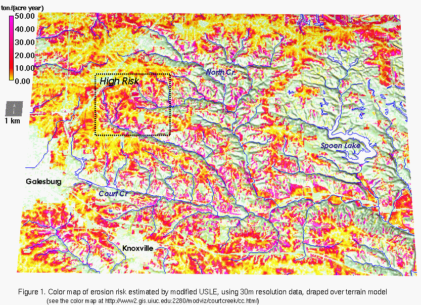
Preliminary results. We have used
the modified USLE model to illustrate a low cost, approximate assessment
of overland erosion risk within the Court Creek watershed (Figure
1). The analysis is based on free, public data (USGS
30m DEM and Land use from
Illinois GIS) using a free software GRASS5.0
(1999 ). The erosion risk analysis based on this limited, relatively low
resolution data indicates that headwater areas are less protected against
erosion than the areas along the bigger streams. Combined overland flow
and stream modeling (to be performed in cooperation with ISWS) will allow
us to evaluate how much impact have these areas on downstream problems
and whether improved protection in headwater areas could reduce flooding,
bank erosion (by reducing the amount of water getting into streams) and
sediment loads. Also, areas with steeper slopes are better protected than
areas with convergent water flow which, in some areas, have higher risk
of erosion due to concentrated water flow and formation of gullies.
Based on the analysis for the entire watershed, we have identified 2 subwatersheds as "high risk" and performed a more detailed study of this area. The original DEM was reinterpolated and smoothed from 30m resolution to 10m resolution to get better representation of terrain geometry, however, no new information was added. We have used modified USLE to identify the "hot spots" with higher risk for soil detachment due to interaction between land use and terrain (Figure 2). The map of topographic risk for gully formation was computed from the modified USLE LS factor (see online image in Mitasova et al 1999b). We have also estimated the potential for net erosion and deposition using the USPED model (see online images in Mitasova et al 1999b). The results of erosion/deposition model indicate that there is some limited potential for deposition within the headwater areas and a significant part of the eroded soil moves only for a short distance. Estimates of sediment delivery to streams from the erosion and deposition model are significantly lower than estimates from the modified USLE with sediment delivery ratio between 10-25%. The results from the USPED model would support some recent observations and hypotheses (Roseboom and Mollahan 1999, Trimble 1999) that often a substantial portion of sediment observed in the streams originates within the streams and its vicinity rather than from overland sediment transport from upland areas. Comparison of the results with field observations as well as further modeling with different land use patterns will be performed to estimate how much eroded soil can be delivered to streams and whether more protection in upland areas could have any substantial impact on water and sediment flow downstream.
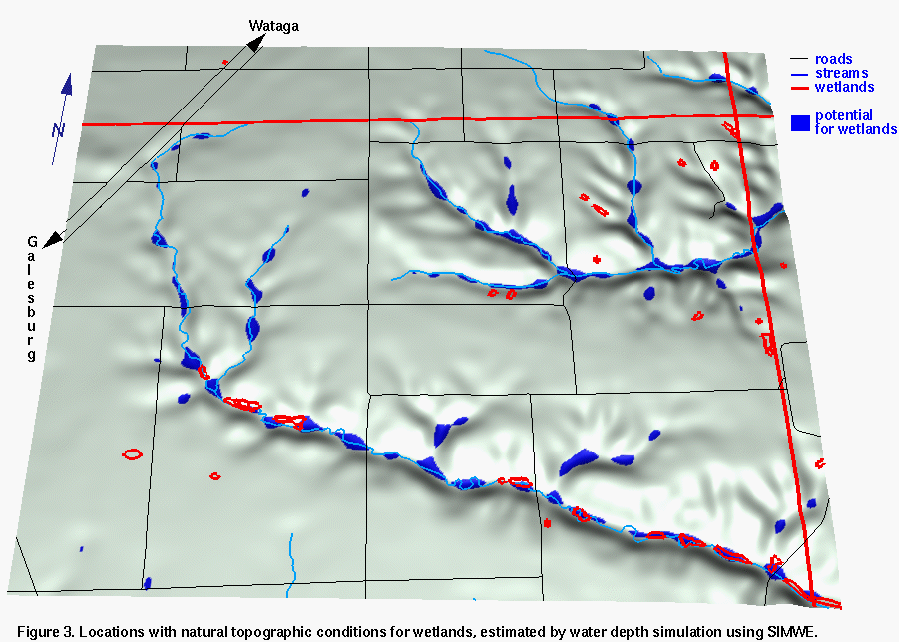
While SIMWE was developed to model erosion processes, its hydrologic submodel supports simulation of water depth in depressions and flat areas allowing us to identify those locations which have natural topographic conditions for wetlands. We have simulated water depth from shallow overland flow (without the impact of channels/streams) to find the areas which can accumulate and hold enough water from surface flow (Figure 3). According to the wetland inventory data from ILGIS, the selected high risk subwatersheds have only 0.32% area covered by wetlands, however, the model indicates that terrain configuration has natural conditions for 2.5% of wetlands, especially in flat locations and depressions along the streams. Due to the low resolution of the DEM, several smaller wetlands were not identified and higher resolution data can reveal even more potential, especially for shallow marsh in upland areas.
Future developments. Our future work for the Court Creek Watershed will focus on the analysis for the planned land use changes and linkage of overland simulation tools with stream/wetland models with focus on evaluation and possible improvements of the watershed implementation plan. We also plan to perform high resolution analysis of selected BMPs to evaluate their optimal implementation and impact on the watershed.
Web site. The results of our research efforts are posted on the
Internet with regular updates at http://www2.gis.uiuc.edu:2280/modviz/courtcreek/cc.html
. This Court Creek research web document is part of a larger web site which
we are developing as a one-stop information source for the watershed
planning committee, land owners, participating agencies and researchers
(see the outline of this web site at:
http://www2.gis.uiuc.edu:2280/modviz/pilot/where.htm
. We welcome any information and links to documents relevant to Court Creek
Watershed and its sustainable land use management.
Citations
Flanagan, D. C., and M. A. Nearing (eds.), 1995, USDA-Water Erosion Prediction Project, NSERL, report no. 10, pp. 1.1- A.1, National Soil Erosion Lab., USDA ARS, Laffayette, IN.
GRASS5.0, 1999:
GRASS Europe (stable) http://www.geog.uni-hannover.de/grass/
GRASS USA: http://www.baylor.edu/~grass/
moving to http://grass.baylor.edu
ILGIS CD-ROM, 1998: http://www.inhs.uiuc.edu/nsdihome/webdocs/cdrom.html
Mitasova H., Mitas L., 1999a GIS-based erosion and deposition modeling for complex terrain. Online tutorial. http://www2.gis.uiuc.edu:2280/modviz/erosion/erosion.html
Mitasova H., Mitas L., Brown, W. M, Johnston D. M., 1999b,
Court Creek Watershed. Online document.
http://www2.gis.uiuc.edu:2280/modviz/courtcreek/cc.html
Mitas, L., Mitasova, H., 1998a, Distributed erosion modeling for effective
erosion prevention Water Resources Research Vol. 34, No. 3, pp. 505-516.
Mitasova, H., Mitas, L., Brown, W. M., Johnston, D., 1998b, Multidimensional
Soil Erosion/deposition Modeling and visualization using GIS. Final report
for USA CERL. University of Illinois,Urbana-Champaign, IL.
http://www2.gis.uiuc.edu:2280/modviz/reports/cerl98/cerlrep98.html
New Strategies for America's Watersheds 1999, Committee on Watershed Management, National Research Council, National Academy Press.
Roseboom, D. and Mollahan, R., 1999, Lake Pittsfield National Monitoring Project. ISWS/IEPA. and personal communication.
Trimble, S.W., 1999, Decreased rates of alluvial sediment storage in the Coon Creek basin, Wisconsin. Science 285, (8), pp. 1244-1246.
Figures
(postscript format, BW - large files but better quality of text than
in the gif images linked into the text)
Figure 1. Erosion
risk estimated by modified USLE using 30m resolution data, draped over
terrain model.
Figure 2. Hot spots
within the subwatersheds with higher erosion risk identified by modified
USLE
Figure 3. Locations
with natural topographic conditions for wetlands, estimated by water depth
simulation using SIMWE.